 We had been hoping for it for months, were expected, We waited - or we grew impatient, it depends – well, There she is : the latest update of Weather4D 2.0.20 is finally available ! On the menu, a major improvement : Assisted charting download and unlimited storage size. To which is added a small number of highly requested features and some bug fixed…
Charts loading
A short video is worth a thousand words :
The number and size of uploaded files is limited only by the storage amount on your mobile device. It can only be deleted by a deliberate action of the user. This development has taken a long time while waiting for the licensing agreements of Geogarage with the hydrographic services, and to set up the technical means to optimize download times.
Cache has been reduced to 100 MB and is now only used to store satellite and OSM views. Don't forget, by displaying BING as a basemap, to zoom in on the landing sites (harbours, Moorings) Where you plan to go in order to have satellite views offline. Otherwise you can always, Approaching the coast, Connect to local cellular networks (roaming charges are abolished in Europe from 15 June 2017, Check with your phone provider).
Let's not forget, however, that access to each publisher's mapping is authorized by an annual subscription on the Dedicated website by Geogarage, and that the cards remain accessible after the expiry date only by renewing the subscription. A procedure is provided to prevent the charts from being accessible while sailing.
Weather Models
AROME models from Météo-France (at 0.025° / 1,5 NM) have been added for : Antilles / Guyana / Polynesia / New Caledonia / Indian Ocean.
All GRIB files can now be exported, Regardless of the model. Import of external files to .grb and .grb.bz2 (Compressed) being already supported.
News
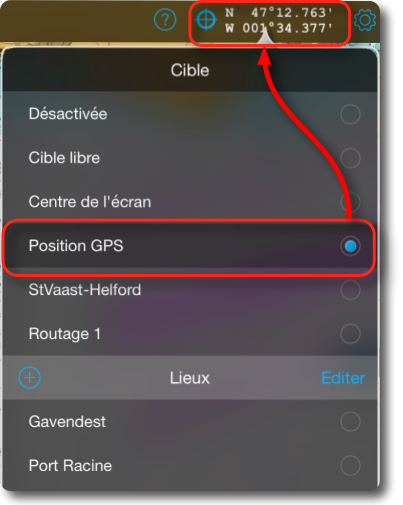
Permanent display of latitude/longitude coordinates all activated targets on the map or all activated saved locations. A coordinate unit setting has been added.
Addition of fine adjustments for NMEA data received from certain sensors :
- Adjustment : to permanently correct the value as a percentage +/–
- Amortization : to delay the data received and smooth the display (scale up to 1 up to 5)
Improvements
- Improved the display of tracks. The distance covered on the bottom has been added to the recorded tracks.
- Possibility of Change Names in the "Edit" mode for all lists by a simple tap on the (Places, routes, tracks, aso.).
- Selecting a recorded location or activating a target on the GPS location displays them in the center of the screen.
This is an update that should meet many expectations and fill in the gaps of the previous card loading system.
–––


Hello Francis
I'm starting to use Weather4D 2.0. I read the guide and I'm doing pretty well but one point bothers me in the routing.
In the guide, you seem to make a distinction (sensible in my opinion) between the engine speed and the minimum sailing speed at which the skipper decides to start the engine. But in practice, the 2 speeds become one and therefore, The sail is replaced by the engine as soon as the speed of the sail becomes lower than that at which the engine is driven.
Why can't we enter the 2 parameters? e.g: below 4 KNTS sailing, I put the engine on, but from that moment on, I go to 6 knts
Merci
The best would be to ask the developer directly contact@weather4d.com
Bonjour
This application is really great and the tutorial is great !!
on the other hand, I have a small problem: As soon as I want to use Saildoc, The app closes automatically ?
Unable to get to the window to select the area
merci