
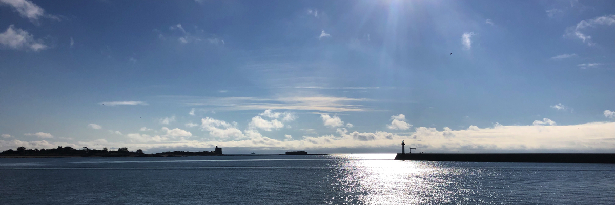
Many sailors who cross the "Big Blue" have known for ages that, if the navigation is relatively easy, the weather represents a particularly difficult constraint to deal. Indeed, if the coasts are mostly clean and the dangers very localized, if the tides are almost insignificant, if the currents are to be considered only in well defined areas, the major difficulty comes from a capricious meteorology, difficult to forecast, which can represent a real danger by its changing moods, sudden, even rough.
Introduction
The Mediterranean is indeed a sea apart. Completely surrounded by an alternation of mountainous reliefs and desert plains, abrupt capes and long beaches, strewn with numerous islands of vast dimensions and with coasts most often steep, it is subject to the coastal effects of strong thermal breezes, katabatic winds, and by various local meteorological phenomena that combine with the general meteorological conditions linked to the movements and conflicts of the air masses that are sweeping over it. A real headache for meteorologists, and even more for the navigators since Ulysse and the Phoenician merchants !
Fortunately, meteorological science has progressed considerably, and high resolution models allow excellent medium term forecasts, i.e. maturity 3 up to 4 days. This is quite adequate since we rarely spend more than 48 hours at sea to cross it from one coast to another. It may be useful to use model ARPEGE up to 4 days by Météo-France which covers all the Mediterranean with a resolution of 6 nautical miles. We will complement for the short distances with AROME up to 36-42 hours and very high resolution (1,5 NM), covering the southern area of French coast down to the south of Sardinia and the Balearic Islands.

Meteo-France AROME weather model 0,025°
For the central and eastern region, from the Tyrrhenian Sea to Turkey, we can use the numerous WRF models offered by the web site OpenSkiron (¹) with resolutions ranging from 12 km to 4 km. Don't forget to stay tuned to local radio alerts concerning very localized phenomena.
Among these phenomena, there is one to which we have to pay particular attention, because extremely dangerous : the Medicane.
Medicane
The term "medicane" is the contraction of "Mediterranean Hurricane ”. Medicanes are subtropical low pressure areas that can form when the sea surface is strongly warmed in summer, causing storm winds and heavy rainfall (²). When the water temperature occasionally exceeds 25-26°C, it can develop significant convective energy at the base of a warm and humid air mass, thus fueling a low pressure system with characteristics equivalent to tropical cyclones. An eye is sometimes visible and the weather phenomena they cause are particularly intense..
They are actually hybrid lows., driven by "tropical" type processes such as latent heat release by convection, and "extra-tropical" type such as horizontal thermal contrasts. Thus, we more accurately refer to "subtropical cyclones” because they are not hurricanes in the true sense of the word.
Medicanes' genesis
(³) The most common criteria and initial states required for the formation of a tropical system are :
- Underlying sea temperature above 25-26°C for a depth of at least 50 meters high.
- Unstable air mass = high CAPE (⁵)
- High humidity in the lower and mean levels of the atmosphere
- Beginning of a preliminary disturbance in the low layers at sea level
- Low wind shearing(change in force or direction) in altitude
- Overlying cold air mass in the upper levels.
These initial conditions are often created by the arrival on the sea of an air mass heated by high temperatures on land, in certain favorable locations around the Mediterranean, and which, pushed out to sea by a combination of factors - orientation of pressure fields, synoptic wind, Coriolis force, in example – is filled with humidity on superheated water with strong evaporation. It is often observed from the flatlands of southeast Spain to the Balearic Islands, between Maghreb and Sardinia, or between Libya and Sicily or Greece. The risks are increased from mid-summer to early winter, when the sea becomes the warmest and remains so for a long time because of its great thermal inertia.
Increasingly frequent

Medicanes are not new phenomena. They have been observed episodically since the introduction of satellite measurements. Until 2015, one was counted every 2 up to 5 years in average. but in recent years we have seen an increase in the frequency of medicanes from mid-summer to late fall, this confirms the increasing probability that this phenomenon will become recurrent with global warming, in the same way as the Mediterranean rainy episodes (cévenols episods).
Medicane "Rolf" on 8 November 2011
France has already experienced this phenomenon in the past. The last one came from 6 until 9 November 2011. « Rolf » particularly affected the Var and Alpes-Maritimes coasts. It falls 250 mm rain in less than 48 hours close to Bormes-les-Mimosas, dont 115 mm by only 12 hours. Wind gusts reached up to 85 knots in Saint-Raphaël and 83 knots in Hyères(⁴).

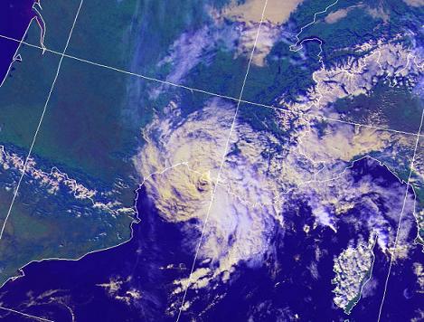
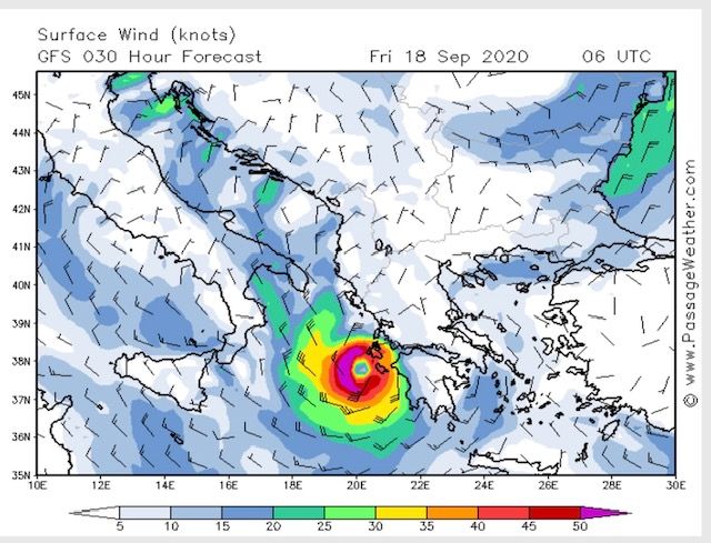
Medicane "Ianos" 17 th 2020
Recently, Greece was hit in the night of 18 until 19 th 2020 by the violent winds and heavy rains of the medicane "Ianos". These have caused flooding in the southern part of the country, from the Peloponnese to the center-east. The strongest winds averaged 60 knots with gusts locally stronger than 85 knots on the Ionian Islands and in particular the Kefalonia Islands, Leucade and Zante. This system also caused waves of over 5 meters offshore. In addition, torrential rains accompanied this episode of bad weather with 100 up to 200 mm surveyed over large areas and locally up to 400 mm on the mountains foothills in central Greece and Peloponnese. The damage to the yachting industry was considerable
Of the 11 until 15 November 2021 the medicane "Blas" has made a surprising trajectory in the south of the western basin, and an exceptional duration of more than 5 days, with intermittent pressure increases as it moves along its trajectory. Unfortunately, I did not capture the end of the phenomenon. But it went up along Sardinia to reach the Ligurian Sea on 15 November, with bursts of 60 up to 70 nodes between Corsica and the Côte d'Azur.
How to forecast and anticipate
With weather models in GRIB format, it is essential to display the CAPE (⁵) to measure the level of the air mass instability. It is also necessary to display the isobars with a reduced spacing (2 mb) with a model such as AROME or WRF 4 km. We can thus better watch the emergence of a low-pressure system in deepening and follow the prediction of its evolution. Warning, the GFS model, even with resolution 0,25°, is not relevant enough to see such a phenomenon.. On the other hand, the ICON EU model of the German DWD has proven to be, for the medicinal product Ianos, much more accurate than the ARPEGE model, anticipating well before him the power and the real course of the storm. It is therefore appropriate, as the most cautious boaters have done, to anticipate according to the most pessimistic model to take shelter.
–––
(¹) Open Skiron
(²) We also talk about T.M.S. (Tropical-like Mediterranean Storm).
(³) Source : Lionel Peyraud 8/11/2011
(⁴) Source : Keraunos
(⁵) CAPE : read Predict storms with Weather4D
–––
I think we are one of those yachtsmen who decided to leave the island of Kefalonia within the hour (Vasiliki) After discovering the 15 September at 2 p.m. the development of the Ianos medicane on the ICON EU model while it had not yet appeared on the other models. The boating friends who live next to the pontoon that we managed to convince to take the same decision were not disappointed with the advice.
Indeed, Jacques, I just watched your video About this episode, Uplifting ! This maxim could be found in the Marin Breton : "Anticipation is the mother of wisdom, the sea rarely forgives negligence".
We suffered "Ianos" in the port of Argostoli (Cephalonia) last September, in the middle of the phenomenon since we saw the eye pass by around 8 a.m. on 18/9. Our boat was anchored in the middle of the harbor with 2 anchors and the whole chain (100m for a water height of 5m). One of the two chains broke but the anchorage resisted. Around us 8 or 9 boats sank in the harbour and in the marina.
So it's very violent and dangerous, but as the depression is very small, it would have been easy to leave Argostoli as soon as the threat was visible on the weather, that is to say, on the morning of 17, to shelter about fifty miles to the N or S.
In 2019, a medicane has also struck Greece and in particular the southern Peloponnese !
It is indeed the "Victoria" depression 12 and 13 November 2019 which caused intense rainfall throughout the Peloponnese, with winds reaching strength 10 Bft. But the centre passed over southern Italy on its way up from Tunisia to Croatia.
