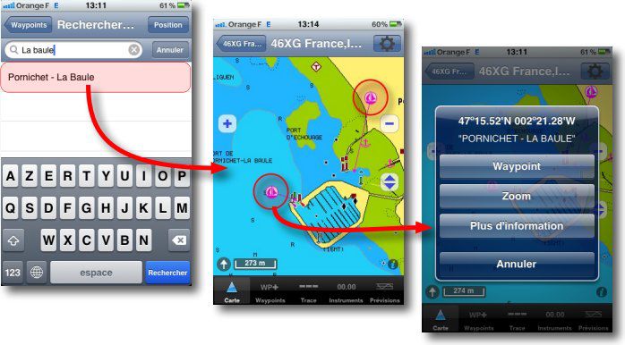
![]() Navionics vector charts contain a number of detailed information for each marina, and sometimes certain anchorages. These places are marked on charts by the symbol shown against.
Navionics vector charts contain a number of detailed information for each marina, and sometimes certain anchorages. These places are marked on charts by the symbol shown against.
This data is called "Navaids" when the information relates to navigation, and "POIs" when dealing with practical and interesting information (Point Of Interest, The "s" is the plural).
Search in iNavX
In Waypoints view there is an option "Port Search". one can enter any part of a name to display all occurrences of what is prompted. Select with a tap the place immediately opens the chart centered on this location.
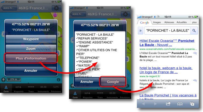
 Then a tap on one of the symbols above opens a popup with the "More Info". Tapping on this option opens a new window with the information available for that place. With a network connection (2G, 3G or WiFi) the "Google" button allows you to open the search engine with the name of this place as the search occurrence, complementing the information sometimes succinct of Navionics charts.
 Important
These textual information are implemented with Navionics charts. They are loaded on your mobile and available without any network connection. More detailed information provided by other applications often requires, just like iNavX's "Google" option, Access to databases, so to the Internet. They are therefore only useful close to the shore.
—


A query on AppStore in the comment for reading Navionics charts, Do they work in offshore navigation? ? I have a so-called 3G iPad, Thank you in advance for your answer.
Everything works, but Google sends me information about the Rance in English, the search being carried out on "River Rance" !
Gil
Unlike Google, hyphens are not neutralized as a space, therefore
'Saint’ Finds Saint-Malo (and others…..)
'Saint Malo’ find nothing !
No big deal but I trust you that the next version neutralizes the dashes
Not very convincing…..
Can't find 'Saint Malo’ while two "sailing icons" appear : respectively "SAINT-MALO – PORT DES SABLONS" and "SAINT-MALO – PORT VAUBAN »
Find "ST MALO" but only give the heading and distance
I have the latest version on the iPad as well as on the iPhone
Jean, I get exactly the same information about Saint-Malo as La Baule on this article screenshots. I sent you my own screenshots by MMS. I don't understand why you don't get them ?
I noticed that the iNavx Navionics charts usually do not have much useful information except perhaps depth. This is a pity because the other area specific Navionics charts (the ones in their own program) have much more interactive information but then you don’t have iNavx.
Also I noticed that C-maps have more information in general available on the charts but then you can not use Apple products only PC Windows.
No justice in this world!
Navionics charts built-in data (Navaids and POIs) seem different in Navionics mobile and Navionics for x-traverse. I think the best could be to ask Navionics about that point.