Global navigation satellite systems GNSS (Global Navigation Satellite System), have become the primary source of Positioning, Navigation and Timing (PNT1) for ships and marine operations. GNSS is also used for the automatic identification system (AIS2). Unfortunately, GNSS is recognized to be vulnerable to jamming and spoofing, intentional or not, that may result in the loss of positioning information, or, still worse, inaccurate positioning information.
Boaters with a critical need for reliable PNT information at all times, It is essential to have alternative and/or resilient methods. The R-Mode (Ranging Mode) or telemetry mode, that uses existing maritime radio signals as positioning sources, is one of these solutions.
The R-Mode project
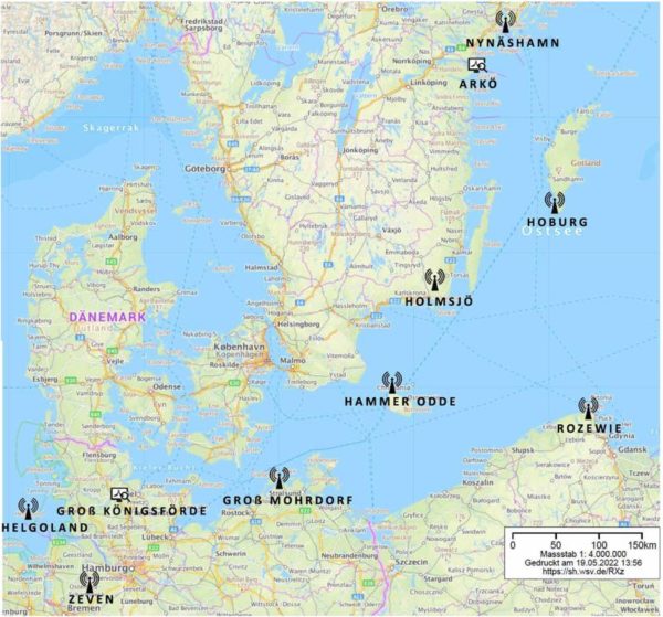
 The project R-Baltic Mode, co-funded by the European Union, is in advanced development. The first feasibility studies were initiated in the Baltic Sea from 2013. This project has become a pioneer in the implementation of a land-based maritime navigation system, regardless of satellite positioning. It should thus make it possible to increase the safety of maritime traffic in the long term.
The project brought together research institutes, national maritime service providers and industry partners. They continued to develop R-Mode technology and verified that it represented an appropriate approach to securing coastal navigation.
In addition, project stakeholders have initiated a process to standardize R-Mode for maritime infrastructure. The first guideline for the very high frequency R-Mode has been completed. Other guidelines, recommendations and performance standards are under development. The project also introduced prototypes of R-Mode devices for ships and coastal sites.
The principle of R-Mode
By combining signals DGPS (³) medium-frequency differentials (MHF) and signals AIS very high frequency (VHF), as well as the eLoran (4) It appeared that positions below 10 meters could be reached. However, these early tests were limited to signal stability studies because there were not enough transmitters installed for positioning. Despite the increase in malicious interference with GNSS signals affecting maritime traffic, the implementation of the R-Mode Baltic studies and tests has been slow, and we had to wait 2020 for meaningful testing to be conducted in the U.S. under the U.S. DoT (Department of Transportation) with prototypes of fixed and mobile transceivers.
How it works ?
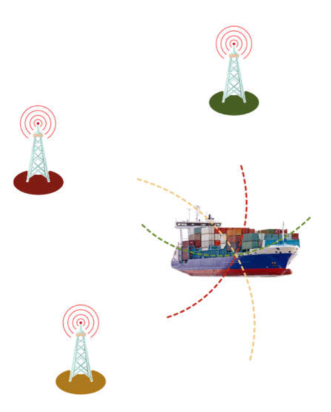
R-Mode uses signals from existing transmitters — i.e., transmitters from medium-frequency DGPS radio beacons about 300 kHz — as telemetry signals. If a receiver can estimate the ranges of three or more transmitters, a position can be determined by Trilateration (see figure 1). This is the same technique used at short distances for terrestrial location with cellular network antennas.
MF beacon transmitters are available worldwide and can be used for positioning at distances of 150 km or more.
The current R-Mode MF signal set has been designed to work with the signals of MSK radio beacons (5) existing. But it can also be combined with other timely signals such as eLoran, AIS or VDES (³) using different frequencies to improve accuracy and coverage. After testing in 2013 and 2014 in the North Sea, the stability and performance obtained of a positioning has been demonstrated less than 10 meters.
Developments underway since 2020
The R-Mode positioning will be based on the estimation of the range of the different emission sites. An evaluation of how potential sources of error affect the performance and reliability of the system in R-Mode will allow consideration of the use of circular and hyperbolic lateralization methods for positioning. Based on existing GNSS receiving platforms, two prototypes of receivers and processors with different levels of integration will be designed. Two R-Mode applications will be developed.
First of all, an existing prototype of a processing unit of PNT data will be upgraded to support the input of raw receiver data in R-Mode. This approach facilitates position calculation based on R-Mode signals transmitted by maritime beacons and/or AIS base stations. In the event of loss of GNSS positioning, the device will automatically provide an R-Mode-based position. Then a Portable Pilot Unit (PPU) will be equipped with an R-Mode module. When GNSS is available, the unit operates in standard mode. In case of GNSS positioning failure, it automatically switches to R-Mode to provide an R-Mode-based position. The PPU unit will provide the navigator with information about the active positioning mode via his multifunctional display. At the end of the project, prototypes will be extensively tested to demonstrate the capability of R-Mode technology.
Constraints
Coupling of different signal emission systems corresponding to different frequencies (DGPS, AIS, VDES, eLoran) imposes perfect time synchronization. Today, it is the atomic clocks of the GNSS satellites that provide this synchronization. This is precisely what the R-Mode system is intended to avoid, since it is intended to serve as a backup system in the event of a GNSS failure or significant interference from satellite signals. In terrestrial telecommunications systems, timing and frequency transfer uses optical fiber networks. This is the subject of functional studies and many tests are underway.
The standardization of R-Mode is also of utmost importance for maritime administrations, port authorities and other service providers to implement harmonised cross-border R-Mode in their infrastructure. Furthermore, navigation equipment suppliers need it for the development of mobile devices that will use R-Mode.
This standardization is therefore a prerequisite for the diffusion of R-Mode technology, because maritime beacons and AIS base stations are designed to meet the standards, IALA's international guidelines and rules, IMO, ITU, IEC and other organizations. Therefore, the implementation of R-Mode technology on these stations requires the modification — or at least the amendment — of existing international standards. The project team will communicate with various standardization committees and international organizations and encourage them to improve and expand the coverage of existing PNT standardization through the implementation of R-Mode technology.
What future ?
This technological return to its roots will no doubt remind old goatees" the heroic times of goniometry and Technifrance's Super Navitech ! However, it is a safe bet that we will not see in production any time soon an R-Mode receiver adapted to yachting available from our shipchandlers. These days, even on our small boats, we are unfortunately not immune to the Jamming or Spoofing on certain seas.
–––
(1) PNT : Positioning, Navigation & Timing (See Glossary)
(2) AIS, the second maritime revolution after the GPS
(³) See Glossary
(4) eLoran (Enhanced Long Range Navigation) advanced Loran-C positioning system, based on terrestrial transmitters.
(5) Minimum Shift Keying = Minimum Shift Keying
———


