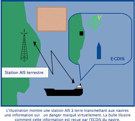
The acronym " VAtoN " means in English Virtual Aid to Navigation. In French : Virtual assistance to navigation (¹).
This concept is an extension of the AIS system. It allows, by means of a spacific AIS transponder located onshore, managed by an administration software, reporting virtually unreported hazard. The position of these hazards is plotted by an AIS target as an appropriate icon. For example, a buoy indicating a flush rock may have been temporarily destroyed by a storm. The VAtoN compensates for the absence of this mark while the maritime services put it back in place. Another example, creating an exclusion area of prohibited anchorage has not yet been an update on ENC charts.
This system could also be applied to harbour guidance services, allowing a harbour master to create an AIS target conducting a ship making the request to a specific docking. This ship would see the target displayed on its navigation screen, making it easier to dock.
The main promoter of this technology, New Zealand's Vesper Marine, has tested a Virtual AIS Beacon that might interest many maritime activities : Marinas or commercial ports, Oil Rigs, aquaculture, Fisheries, etc,. The functions of this beacon are :
- Warn ships of non physically marked danger.
- Mark navigation channels to improve the transition from one buoy to another in condition of poor visibility.
- Marking frequently modified navigation areas (draft, Air draft, tidal levels, etc,).
- Mark visible and hidden hazards, such bridges, Muffers, reefs or shellfish beds.
- Mark areas where grounds are often modified (sandbanks or mud banks) continuously showing the position of the hazards.
- Temporarily create a security cordon around an event (yacht race, Ship grounded) or a protected area into which no vessel may enter.
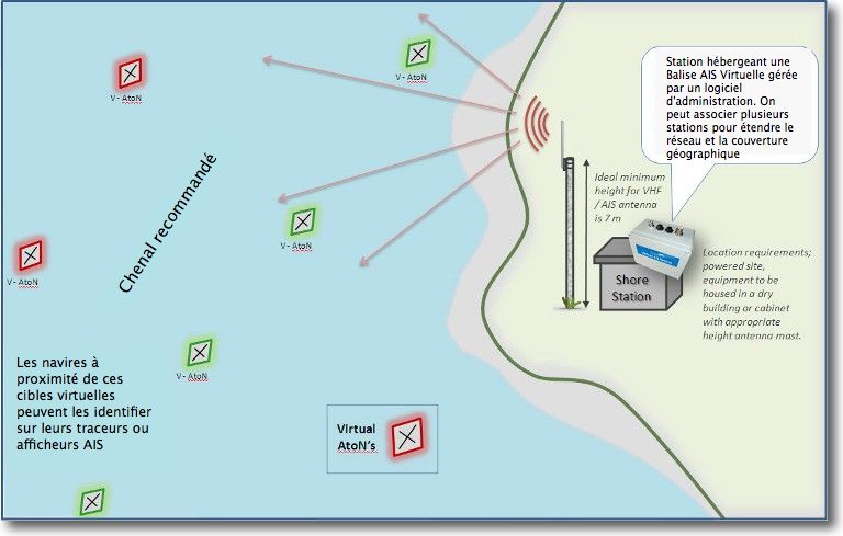
One of many examples of using the Virtual AIS Beacon is to mark a shipping channel. It may be necessary to increase the number of existing physical buoys or to materialize a temporary route, as in the example below :
No doubt that with the proliferation of AIS transponders and devices capable of displaying targets, as ECDIS, chartplotters, navigation software or dedicated displays, This technology is expected to develop in the near future. Its implementation cost is considerably lower than RADAR-type equipment. It should naturally find its place in the VTS (²).
—
(¹) Source PANBO
(²) Vessel Traffic Service. See Glossary
—


