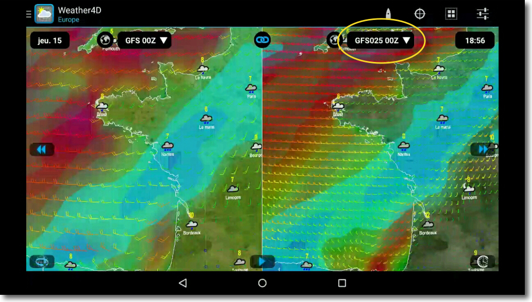
 By a corrected notification on 23 December 2014 (¹), with NWS (National Weather Service) NOAA announced a major update to its GFS weather prediction model to be effective in mid-January 2015. Actually, This model has been partially available on an experimental basis since the beginning of December.
NOTE
The Global Forecast System (GFS) is a weather forecasting model produced by the National Centers for Environmental Prediction (NCEP) dependent on the NWS. Dozens of variables (²) are available through this dataset, from the temperatures, winds and precipitation down to soil moisture and atmospheric ozone concentration. The entire world is covered by the current GFS model with a horizontal resolution of 27 km between grid points up to 10 days. The horizontal resolution is 70 km for forecasts between one week and two weeks. The GFS model is a coupled model, Composed of four distinct models (An atmospheric model, An ocean model, A terrestrial model, and a sea ice model), that compete together to give an accurate picture of weather conditions. Changes are regularly made to the GFS model to improve the performance and accuracy of the forecasts. Mesh data is available for download via NOMADS servers (National Operational Model Archive and Distribution System) and widely used by app developers around the world.
New GFS model / Global Spectral Model V.12.0.0
The National Centers for Environmental Prediction (NCEP) Updated the GFS Global Analysis and Prediction System, What includes, among many improvements :
- Modifying Model Components
- Increased horizontal resolution
- Addition of a horizontal grid data output of 0,25 Degrees
- Adding new data fields
- Changing product naming conventions
- Changing the Refresh of Products
- Changing the impact on downstream models
Many other improvements concern data acquisition and assimilation, and in particular satellite observation data, the consideration of new surface variables (land and ocean), Modeling, the rhythms of the calculations, etc,.
The resolution of the model is doubled :
- Increased horizontal resolution for the first segment of the forecast reduced from ≈27 km to ≈13 km, with an extended forecast of 192 hours to 240 hours steps.
- Increased horizontal resolution for the second segment reduced from ≈84 km to ≈35 km, with a forecast of 240 hours to 384 hours steps.
Analysis
A retrospective comparative analysis of the new GFS model against the current model, and also to the European model of the ECMWF, focused on certain sensitive weather events, such as Hurricane "Sandy", was presented by NCEP (³). It was able to highlight the following results :
- Improved precipitation qualification results.
- Improving hurricane tracks in the Atlantic and Western Pacific, but deteriorated in the eastern Pacific.
- Hurricane intensity errors reduced in all basins.
- Reduced Storm Track Errors at Mid-Latitudes.
- Reduction in the global mean temperature trend in the upper troposphere. Improved wind data, Tropospheric winds strengthened but stratospheric winds slightly weakened.
- Improved surface anomaly correlation rate 500 hPa in both the Northern and Southern Hemispheres.
Interestingly, the NCEP, whose accuracy of the models had shown shortcomings compared to those of the ECMWF in the path of Hurricane Sandy in October 2012, with the dramatic consequences that we know, has worked hard to catch up.
New GFS output product in native GRIB-2 format :
- 0.25° horizontal grid (15 NM), Date 0 up to 240 hours steps (0 up to 10 j.) with 3 hours steps, and 240 up to 384 hours steps (10 up to 16 j.) with 12 hours steps.
- Medium resolution models of 0.5° and 1° now use the same characteristics (Deadlines and not).
- The low-resolution 2.5° model is planned to be abandoned in the short term because it is rarely used.
- Native GRIB-2 output format, and no longer GRIB-1 converted.
The operational availability of these new products is estimated around mid-January 2015 (⁴). It has been in the test phase since the beginning of December 2014.
What improvements for recreational boating ?
The availability of the GRIB file of the new GFS model with a 0.25° mesh (15NM), and therefore a data density four times higher than the 0.5° model, will undoubtedly bring a real improvement in global forecasts, particularly in coastal areas and closed basins (Mediterranean Sea, Baltic Sea) where the impact of terrestrial data is significant. Integration of new relevant data such as satellite wind data, Accelerated data acquisition speed, better consideration of certain variables such as those from ice analysis or soil surface, contribute to the overall improvement of the model. In addition, the impact will also be noticeable on WRF fine-knit models, themselves impacted by the GFS model.
This therefore promises a significant advance in global predictions for browsers, thanks to a free distribution by the American administration. Still waiting for the European Meteorological Centre's forecasts to be made publicly available, But that's another story… (⁵)
—
(¹) Technical Implementation Note 14-46 Corrected
(²) Until 366 Data spread over 64 Elevation levels.
(³) www.emc.ncep.noaa.gov/GFS/ppt/GFS implementation_Q1FY15_review_v4.pptx
(⁴) http://www.nco.ncep.noaa.gov/pmb/products/gfs/index.shtml.upgrade
(⁵) Plea for free European data
—


Bonjour,
Congratulations for your Blog... I'm not in the Apple galaxy, but I'm interested in it. In your introduction, You write : "The whole world is covered by the current GFS model with a horizontal resolution of 27 km »
Unless I'm mistaken,, The resolution is 0.5° or 30 miles, or about 57 Miles... Is it a typo? ??? or am I eating myself ???
Sincerely
Michael
The horizontal resolution of 27 km, which has just been reduced to 13 km, relates to the internal forecasting model called GDAS. The GFS model at 0.5° or 0.25°, from the GDAS in part, is for GRIB format output for public use.
The Americans have imposed GPS to the detriment of Glonass and Galileo, by being the first to make it free to use for the general public. They do the same now with the weather data. Perhaps they will also continue with nautical charts ? This already starts with the NOAA charts.
It's a shame that France and Europe are lagging behind on this subject.
I was also able to test this model with W4d android. It's great on land, at sea a little less the files are much larger than the classic GFS. From the Marquesas Islands, a bit of a difficult weather situation to go to Tahiti. 3 Depressions, the second classified as a level cyclone 1. Thereafter it will weaken, the third will even fill in, but before leaving, a forecast of such finesse for 10 days, covering the whole world, Nothing better at the moment and in case of doubt, at sea I go back to good old GFS, and above all I can't wait for Olivier to implement it on the IOS version of W4D.