You have certainly heard the song by Helmut Fritz “It annoys me” ? She will make a good number of holidaymakers dance this summer in campsites and on the beaches. Well me, what annoys me, it is the disbelief of a certain number, still today, about iPhone GPS accuracy. Isn't it stupid, isn't it ?
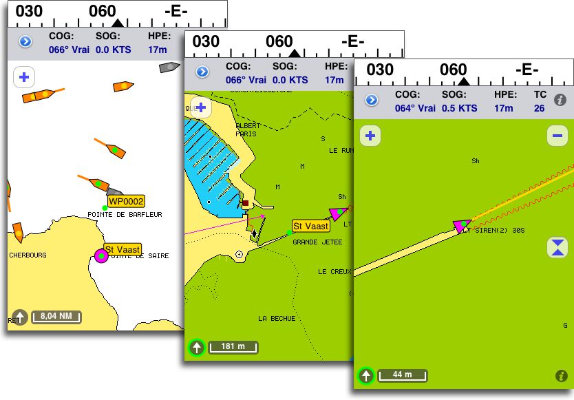
I have performed a few days ago a small experiment, during a call in the charming little harbour of Saint-Vaast-La-Hougue. In arrival, berthing at high tide alongside the north end of Grande Jetée, where waiting fishermen are often moored. You can see in the screenshots below my location with my iPhone 3GS. The pier makes 4 meters wide over its entire length (360 m.). Note the green dot in the center of the position icon, which is the exact location provided by the GPS. You can see that iNavX app displays an horizontal position error (HPE) calculated by GPS 17 meters high. The actual position is within a circle of less than 3 meters diameter.

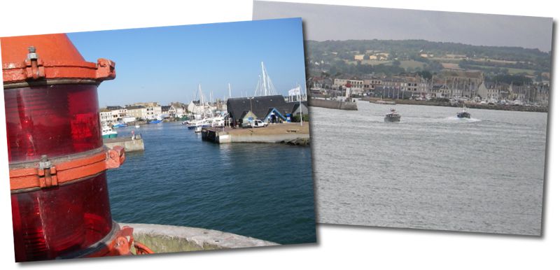
Berthing at the end of the Grande Jetée, under the lighthouse. Position iPhone 3GS.
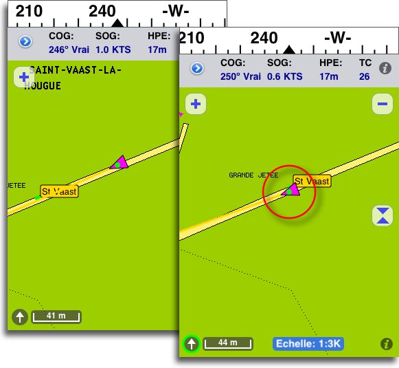
I specify that connections to networks (Wifi/3G) were cut so as not to interfere with GPS location. I then walked along the pier to position myself on the waypoint, created last year, which marks a ladder placed directly above a perfectly clean stranding area at the quayside allowing careening at low tide. Placed above this ladder, I am on the following images 1m50 away from the waypoint.

At the height of the ladder, position dot is 1.50m off waypoint.
You can also see that, from recent versions of the iOS system and iNavX, course speed (SOG) is now displayed from 0,5 knots. Last year, up to 3 knots SOG was not displayed ! Moreover, GPS chipsets in iPhone 4 and iPads 1 and 2 are even more efficient than that of the 3GS.
I hope that this little demonstration will finally convince the unbelievers. And if by chance your bow takes you to the Cotentin, do not miss a call in Saint-Vaast, the oysters are famous there !

—
Related articles :
iPhone built-in GPS : some details
iPhone 4 : location componants
iPad 3G, Initial information about built-in GPS
—


5 star article brilliant. I am new to blogging and you used a langauge I can understand
Thanks, you are welcome 🙂
J’ai pu tester L’Ipad (Ipad 1 3G) et INavX durant 5 jours en conditions humides, à bord d’un Tricat 23, 5. L’Ipad, protégé par une pochette étanche Dripro, était accroché par la sangle de la pochette à la capote protégeant la descente, en position portrait. C’était le seul outil de navigation embarqué, en dehors du compas du bord (J’avais évidemment les cartes papier de notre périmètre de navigation, elles ne sont pas sorties du sac). Quelques point méritent attention :
– Penser impérativement à verrouiller le basculement automatique en mode paysage.
– Autonomie surprenante : After 12 heures de navigation autour de Belle-île, il restait encore 33 % de charge batterie ! (Penser à mettre Wifi, Bluetooth et 3G sur off)
– By beautiful sea, handling is incredibly easy (30 seconds are enough to modify a route made impassable following a change in wind)
– When the boat starts to spray crew and equipment, things are getting complicated : Soaked fingers on a dripping screen give fancy screen responses ; therefore provide sponge, towel and cloth, possibly a pair of waterproof gloves.
– The precision is quite astonishing (the circle of uncertainty has barely more than a meter in radius!).
– In the absence of a WiFi connection, iPhone owners 4 can use their 3G chip to get GRIB files, handling to be done at the stopover, dry and quiet.
– Mention spéciale à AyeTidesXL,un plus indispensable pour beacher de toute sérénité.
En résumé, un outil qui fera la joie de tous ceux qui veulent naviguer « électro » sans avoir d’installation électrique à bord.
Gil.
Merci pour ce retour d’expérience en navigation particulièrement humide. Sur ce type de bateau, the Waterproof case de Andres Industries, malgré son prix, serait tout à fait justifié.
Ce commentaire pourra achever de convaincre les plus sceptiques 🙂
Nous avons utilisé un Ipad 1-3G avec la cartographie Navionics lors de notre récente navigation de Puerto Williams à Puerto Natales en Patagonie Chilienne.
Outre la facilité d’utilisation qui n’est plus à décrire, we were impressed by the accuracy of the GPS, and also cartography which has, in many cases, was better than that of CMap from the on-board installation and other maps used on PC.
Installation you board: SIMRAD with CMap mapping, NICE rugged desktop PC 3150 under XP pro SP3 with MaxSea 12.6, Scannav 10, Ozi Explorer and Open CPN with Raster or Vector maps depending on the sources. GSP Simrad and Furuno GP32. Mux Shipmodul AIS.
Consequences: purchase of two 3G Ipads and an MBP 15″!
For the record, we completed a stage with only the Ipad and the paper maps after a crash of XP, which required its reinstallation, and a CMAP map that is far too discreet.
In our opinion, the iPad has its place on board. (43 sailboat″) and its use in the cockpit under a waterproof case will be very appreciated as a repeater of the fixed PC.
Congratulations again for your site that I recently discovered, and shame be on the journalists who shamelessly plunder the sites without citing the authors.
Sincerely
Alain
I used iNavX on an iPad this summer 1 wifi, connected to a small bluetooth GPS. Just jailbreak the iPad and it works perfectly. Astonishment, you must leave wifi activated on the iPad (even without network) because otherwise it does not recognize the GPS position. Several tests, with Navionics on iPhone, a standalone Garmin GPS and SHOM maps, a Magellan fixed GPS and maps in WGS84, as well as corrected probe lines also showed the relevance of the solution. And we realize that the only uncertainty sometimes comes from the lack of precision of the maps !
The iPad with its ten hours of battery life, its small footprint, its side ‘press and forget’’ have advantageously replaced the laptop which only asks to wallow as soon as it moves a little and which always threatens to crash when it is not necessary…
INavX is a little expensive but worth it, although improvements in the economy would be welcome.
Accuracy regarding navigation, it was on the other side of the tip of Cotentin, in the Channel Islands, where the maps are sufficiently precise to carry out this type of comparison and testing.
East – it is possible for a wifi ipad to exploit this excellent GPS signal coming from an iphone located nearby via bluetooth or wifi without any other equipment ? (This theme may have already been discussed on this blog ?)
Indeed the subject was discussed in this post. Jean Debeze recently sent me an email exchange with Rich Ray (iNavX developer) which confirms, supporting screenshots, that it works with an iPhone 4 serving as GPS for a WiFi iPad.