
Since the start of the navigation season, many boaters have found an increasing number of errors on Navionics charts, following recent updates, all media. All over Europe, Germany, Baltic States, French coasts of the Channel and until Spain, appeared non-existent channels and erroneous soundings, missing soundings, Missing information, Conflicting bathymetric information depending on zoom levels, and so on. Most importantly, these findings are made by long-time regular users of Navionics charting, experienced sailors.
[Corrective update 26 August 2015]
[October Corrigendum Update 2 2015] See end of entry.
The first to inform me of this was Jochen Lührs, iNavX's German translator, with whom I recently collaborated in the writing of iNavX tutorial in this language. He sent Navionics support a documented email with screenshots of the many defects observed during his summer sailings. At the same time, Several threads on the subject have been developed on the French forum Hisse-et-Ho Where the revolt is organized. Some contributors to this forum have also sent to the help@navionics.com Their findings. This forum is public, I extract some revealing quotes from it, the authors will recognize themselves :
" Back from Holland, I noticed many differences between actual soundings (corrected potential gap of tides) and the sounder's values. Back in France, I am surprised to find out about new versions of the Navionics charts a channel around the island of Tatihou close to St-Vaast-la-Hougue. ”
" I did more than a few years ago 6 months attempting to report to Navionics that many soundings contours in the small port of Burela in Galicia were completely crazy over the official charts and all other electronic charts soundings. ”
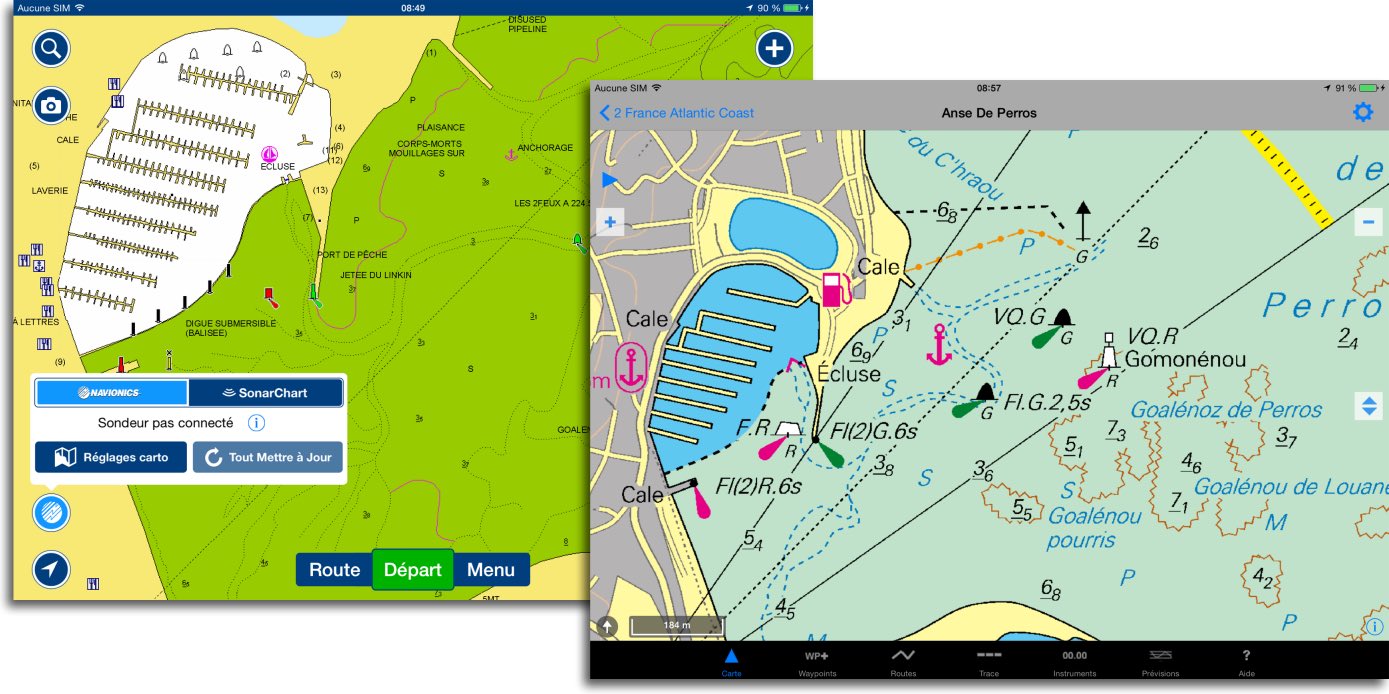
" […] by comparing, about Perros-Guirec, Navionics SonarChart updated a few days ago with the ordinary Navionics chart : Martian canals spring up on the foreshore in front of the port, and, Oh surprise, There are now two benches which discover before two pontoons, including mine (For those who don't know : the underwater quay that surrounds the port provides at least 2,5 m water […] everywhere). ”
SO, what happens to Navionics ? I have promoted this charting, mainly for iNavX, I have it widely used and considered so far as being certainly the better designed and better update of private vector charts. Unfortunately, marketing orientation of Navionics to risky choices confirm the fears I expressed five years ago (¹). The recent deterioration of charting quality is undoubtedly the consequence.
SonarCharts and Community Sharing
 The concern to maintain the Navionics Boating application (ex-Navionics Marine) at the forefront of mobile navigation apps has generated the bright idea of offering users to power, by their own identified of soundings, bathymetric charts called SonarChart. These charts with the sole purpose to improve the marine recreational fisheries ground contours. Navionics has developed support of different sounders among the most used by boaters. The data collected in real time during journeys is supposed to feed a community database for this purpose.
However, it seems that the reality is a little different, and that SonarChart have only actually collected interpolated details. Moreover, what credibility should be given to the data collected by amateur sailors ? As these Internet users express :
" I find it absolutely implausible, even criminal, Navionics alters its charts […] using soundings provided by users who are not really able to give absolutely accurate information. ”
" When we know how seriously the hydrographic survey by official services are performed (even if they are old) One can be stunned by the fact that an ordinary boater, often unable to do a calculation of tide with twelfths rule, can transmit information affecting the safety of the ships to a provider of electronic charts. ”
I agree with these remarks all the more because I have already expressed myself in this direction in the past (¹). But that's not the worst.
Navionics nautical charts and SonarCharts
In Navionics Boating app, you can switch between the 'nautical' so-called chart and SonarChart. The first being to navigation use and the second to fishing use. This is what Navionics' customer service expresses to a user in response to an error report, I quote :
" […] We also remind you that the layer Sonarchart is not suitable for a safe navigation, it is useful for locating fishing areas at any depth level. While navigating, make sure you have activated the nautical charts.
Navionics Customer Service".
Surprising response regard to maritime safety. Even more surprising than the recent updates of the Navionics charts (all media) provide many mistakes that seem directly from data displayed in the SonarChart, unable to correct in iNavX or in a chartplotter because they have no alternative to display.
Below the two versions of the same chart in Boating HD, But there seems to be a reversal. The chart on the right should be the Navionics "navigation", and I hope that the absence of soundings has been corrected subsequently (I have not subscribed to Navionics+).

Navionics Chart (navigation) Left, SonarChart on the right. Charts appear reversed. I have soundigs at left, not at right. This is not the latest update, however.
Left, The two channels in blue do not exist and present a risk of grounding. This area is covered with oyster beds, only motorboats pass on above mid-tide. Found the same chart in the last Navionics Gold 46XG for iNavX update (from the X-Traverse server) :

Left non-existing channels issued from SonarChart in iNavX. Right the most recent raster chart NV Chart from SHOM
Another example in Perros-Guirec, two successive updates with appearance of "Martian canals". (See above) mentioned by a contributor. It is understood that these channels are totally far-fetched.

Two successive versions of SonarChart. More and more misinformation.
Below, the Navionics "navigation" version (Correct) compared to the raster NV Chart issued from SHOM. Found but minor details the same Navionics chart in iNavX (Indeed the alignment of the two leading lights at 224° is not drawn).
The map on the left in Boating HD by selecting "Navionics" has not been changed and looks correct.
Public or private charts ?
If Navionics does not quickly become aware of the rapid degradation of its products, It is likely that boaters will turn to other more secured solutions. With the rapid advent of’Open Data' within European administrations, boaters will certainly access public charting at lower costs, or even free soon. Today, It is already possible to use in Weather4D Android all SHOM electronic raster charts catalog (60 €/year) , UKHO, and other official publishers. Soon it will be available in a future iOS version. The SEAiq application also allows to use the official vector charting ENC S-57.
Private vector solutions (Transas TX-97, Navionics charts, BlueChart, C-Map charts, aso.) should a sacred level of excellence to maintain their economic model the day that European hydrographic services will be free as those from NOAA. Also in order to face the outsiders who have been appearing on the market for some time (²). And it is certainly not a random bathymetry that will make the difference, We will have to put a little more seriousness and professionalism into it.
[Corrective update 26 August 2015]
The Navionics 46XG update dated the 26 August 2015, available for iNavX on the website X-Traverse.com, has made the disputed "Martian channels" disappear. This update has not yet made an announcement by Fugawi mail as usual when major updates. Thanks to the user who just warned me. No info about the other files.

[Correcting update 17 October 2015]
The latest October Updates removed bathymetric data from SonarCharts from all standard charts. But Navionics is not abandoning the SonarCharts, Major selling point.
___
(¹) Navionics Mobile and Community Sharing
(²) Raster charts... the come back
___
I have been sailing for several years in the Eastern Mediterranean and I blamed the bathymetry errors on the poor quality of the official mapping bodies. But I am surprised that these errors also exist in Europe and in France.
As for Sonarchart, It's a hoax. Currently (24/09/15 12:30), I'm at anchor at Capo Colonne, to Crotone. Sonarchart gives me funds of 0,5 1m in the whole area, while the pollster, I have 5 meters high.