
The latest version of the iOS operating system for iPad, iPhone and iPod Touch have caused their share of compatibility updates. This time, with iOS7, developers have had hard work to put their interfaces in accordance. As far as we are concerned, the latest versions optimized for iOS7 to date are :
- iNavX 3.7.0
- iSailor 1.5.5
- AyeTides 3.0 (iPhone) and AyeTides XL 2.0 (iPad )
- Weather4D 1.3.2 and Weather4D PRO 1.3.7
iNavX
It is the application that has the most adaptations of the interface to the new system. Functionally, nothing new, no particular improvement in responsiveness in the various manipulations.


iSailor
Transas is taking advantage of this update to make some improvements, mostly :
- Improvements of the auto loading and Chart Generalization algorithm on large and small scales.
- Cross Track Distance (XTD) is now adjustable for the each leg of the route separately.
- Cross Track Distance (XTD) zone can be presented graphically on the chart layer.
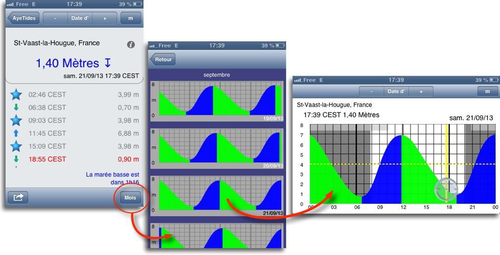
AyeTides and AyeTides XL
August Hahn took this update to bring significant improvements in both versions for iPhone and iPad.
- Additions for the Europe of the Current predictions for hydrographic services referenced locations. At first database for the English Channel with more than one hundred geographical locations.
- Display predictions current hourly or hours of max / min currents.
- Print and sending by email the day predictions.

- For AyeTides on iPhone, adding a page of graphical presentation of daily predictions for actual month and following month.
 Weather4D and Weather4D PRO

In addition to optimizing for iOS7, What's new is :
- Display GRIB file size in area settings dialog box top banner.
- Added My Ocean 1/12° Global Current Model – 24h – 7j.
- Addition of the GCWF model for Greece.
Other applications, as Plan2Nav and Garmin BlueChart not yet updated. About Navionics Marine, I guess we'll have to go through the purchase of the optional Navionics , which I do not intend to do.
Having Navionix (IPhone) and Maxsea (iPad) the latter is stunning on approach with the 3D photo-map overlay; on the other hand, the map is very late in the southern Loire area (Port Morin and Fromentine).
If these apps replace a GPS Plotter remains the problem of the sonar !!! which is usually delivered with (Negligible price difference)… Is there an app or a box + app to retrieve a probe message ???
Sincerely
Bonjour,
I can't find how to see the currents on AyeTides XL, How to do it ?
Philippe
Currents are not "displayed", These are the hourly current predictions for the stations referenced on the map by the. Enlarge the screenshot to better understand.
I withdraw my question. I just found out that when forecasts are displayed, The instrument banner is not visualized (No triangle). We learn every day!
Bonjour,
I just updated iOS 7, on inavX, the triangle that allows the indications of the instruments to be superimposed on the map has disappeared. I haven't changed any settings so far. Do you need to change anything to make them appear? Thank you for your always valuable advice.
Daniel.
Bonjour
I did the iOS update 6 towards 7; The blue triangle that makes the instruments appear/disappear is always active, Apart from a few cosmetic changes, nothing special about iNavx.
this concerns an Ipad 3 with GPS from 32 GB RAM.
Kind regards
René
Thank you for your answer, no I don't sail with the CMN but with the CNSN (Club Nautique Saint Nazaire Nantes) club that includes 140 about fifteen skippers on two boats of 10 m a Dehler 32 and an Oceanis 323 based in La Turballe.
Maxsea in some cases purchased from the Hémon-MGEM company in La Turballe (maintenance by Eric pro on trawlers) + two MTT tablets equipped with Navionics.
OK I'm going to start on the 4S, hoping that all the applications follow.
Will you be present in La Rochelle next Friday? ?
Merci, Kind regards, Patrice Cart-Tanneur.
Member of a habitable sailing club, I always follow your newsletters with interest.
Surely, Here you can only scan the IOS7 with the iNavX applications and its add-ons, for iPhone and iPad.
The fact remains that those who, Like me, have Navionics on an old iPhone 3GS in a Magellan waterproof case as a backup, while having their iPhone 4S with the same apps, This poses a serious problem. Indeed, the 3GS would not support the IOS update 7. So if by mistake you do this last update for your iPhone 4S, by saving and synchronizing everything on your microphone you stick the souk in your 3GS.
Well you'll tell me I still have Maxsea (both V12 and TimeZero versions), but still, it's handy to find as I had a raster mapping error on the northern bay of Stornoway in the Outer Hebrides. This is in confirmation of one of your previous posts.
Sincerely.
You sail with the CMN ? I also still have a 3GS at the end of its life. I don't see how to backup your iPhone 4S to iTunes (also that of my wife, and we use the same Apple account) is causing problems with your 3GS. Backups and updates are completely independent for each device referenced on iTunes, whether on a Mac or PC. There can be no restore on your 3GS with the backup of your 4S, unless you expressly state so, which is unlikely to happen.