
The year 2015 barely started, the developers are already giving us the developments of their applications, probably made between two glasses of champagne during the holidays. I consider iNavX and iSailor as the two best navigation apps so far under iOS. These are the ones that offer the most extensive functions and the selection of the best charts. They each have their qualities and faults., and I take advantage of the new features brought by their recent update to try a quick function/price comparison.
Warning, this exercise is associated with a snapshot vision, valid today but quickly obsolete tomorrow, as changes are rapid in this domain. On the other hand, it is always difficult to distinguish between objective and subjective aspects in a comparison., I was already confronted in the past (¹).
 iNavX 4.1.3
This version, delivered for a few days, essentially adds improvements to the many functions already present.
- Graphic meteogram
Associated with weather display option provided as optional with Theyr.com (²), a tap anywhere on the chart when the forecasts are displayed provides access to data meteogram for this location. The choice of units is made in the application preferences.

- Export of waypoints, routes and tracks files
In addition to transfers to the X-Traverse account, which allows you to save this data, iNavX allows you to export by the "Open in" function, via AirDrop, and also to iCloud Drive (If enabled in the device settings).

- Barometric pressure
With iPhones 6 and 6+ A built-in air pressure sensor appeared. iNavX displays the barometric 'BPR' pressure in instruments banner, with a graphical zoom recording the pressure of the last 24 hours steps.

 iSailor 1.7.2
This version provides new options by subscriptions and improvement claimed for a long time : the ability to enable and disable the display of lights sectors on the chart.
- Tides and Tidal Currents
The tide calculation in iSailor is carried out on the basis of the four main harmonics as well as the corrections in shallow water. The calculation process is based on the Simplified Harmonic Method of Tide Predictions which can be found in various publications, such as the Admiralty Tide Tables (British Admiralty Tide Tables). It is specified that the results of this method may have "minor differences" with the official tide tables. It's an option per yearly subscription.

- Navigation Guides
They contain all the marinas, commercial and fishing harbours, and anchorages in a geographical area, includes detailed information as the means of contact (VHF, telephone, email, website), Facilities, Access, etc,. The navigation guides are accessible through a new tab in the side drawer. The first two areas available are the Mediterranean and the Caribbean. Sites are represented on the chart by specific icons, a tap to access the information in the side drawer. Each guide is an option per yearly subscription.

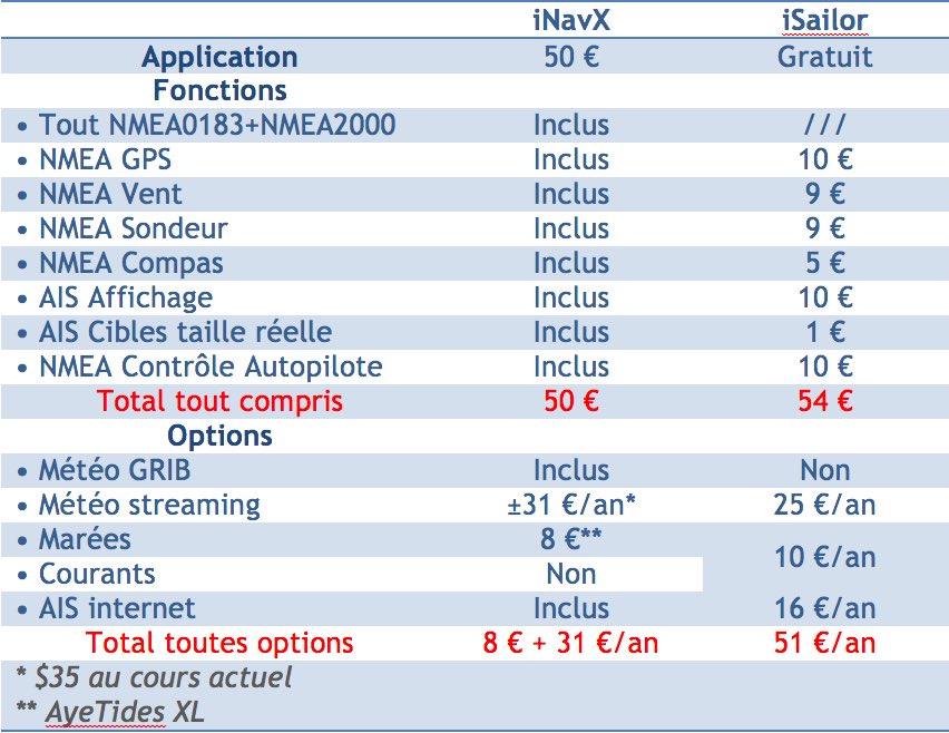
Features comparison
Both apps offer the same basic functions. In addition to the management of waypoints, routes and tracks files, we find the Alarms and the Alerts fairly complete (Waypoint enabled, anchor, AIS, WiFi connection, aso.) but with a significantly different treatment. Functions’import/export are much more numerous in iNavX, as well as chart display settings that provide a much wider range of options.
The Chart management (purchase, download, update) is much easy with iSailor, since the purchases are integrated (in-app). Unlike iNavX where purchases via the X-Traverse server are a real headache for users.
About advanced functions, NMEA interface, support AIS, data Weather report, the prize goes to iNavX that showed from the beginning a desire for integration with all navigation instruments, using NMEA0183 and NMEA2000 support and TCP/IP protocol. A request and display feature of GRIB weather files via X-Traverse , or via Saildocs Server with Mail or satellite messaging (Iridium, XGate). iNavX does not directly provide the tides calculation, but interfaces with the app AyeTides which proposes the water levels of 10.000 Stations around the world. iSailor offers connections NMEA0183, but limited to navigational instruments : GPS, Vent, Sounder, AIS. However the option Tides & Current displays vectors of currents on the chart with direction and instant speed in real time. Remains to check the accuracy.
Both applications converge on the management and AIS target display, with CPA/TCPA calculation, ROT, Approach Alarms. AIS can be received via NMEA in direct connection to the instruments (receiver or transceiver) or by Internet reception.
Finally, a fundamental difference concerns charting, which I will talk about below : iNavX proposes the use of a major charting catalogue from different publishers, vector charts with Navionics, raster with all others. iSailor offers only TX-97 vector charts from its publisher Transas.
Regarding the two user interfaces, i.e. ergonomics, I prefer not to comment. The appreciation of one or the other is too personal. Let's talk about the prices instead, much more objective comparison.
All-inclusive prices
Two economic models are opposed : A paid application but whose (nearly) all advanced features are provided, and a free app where (nearly) All advanced features are paid for. Let the best one win ! Warning, These prices from the beginning 2015 are a snapshot, they are likely to evolve in the future.
Charting
For the comparison to be consistent, I will only compare vector maps Navionics charts (iNavX) and Transas TX-97 (iSailor).
Regions area are much more fragmented with Transas than with Navionics. For a comparison to be valid, Equivalent geographical areas must be considered. Difficult. In addition, large areas of Navionics penalize mariners attending only limited coastal areas, while the addition of reduced areas with Transas penalize those who cross vast areas. Let us take two examples which concern Western Europe and the Western Mediterranean.
To get the equivalent of the region Europe Navionics 46XG ($80 ± 69 €) you have to add 175 € Transas charts ! But all boaters navigate not the Belgium to the Azores and the Canary Islands to Corsica. Knowing that each European charting area is sold 25 €, for the price of a Navionics 46XG I can buy almost three Transas charts region, for example South England + Channel + Atlantic up to Vigo. What will largely suffice to many boaters.
To get the equivalent of the region Mediterranean Navionics 43XG ($80 ± 69 €), you have to add 150 € Transas charts region, not exceeding the Turkey coasts. Once again, not everyone will sail in Greece, but even must pay 75 € to cover the French coast, Balearic Islands, Corsica and Sardinia, preferred destinations by our compatriots.
Regardless of the quality of these charts, on which I have already expressed myself sufficiently (³), It can be seen that the prices, despite a misleading division, are practically equivalent for geographical areas of an extent normally frequented by a majority of boaters. Navionics will be more affordable for those who sail the open sea, and Transas for small coastal navigation. But overall it makes sense.
Finally, Important accuracy : the Navionics charts must be renewed every year, so that you can continue to update them, at the initial purchase price. It is therefore nothing more and nothing less than a subscription (to which no one is obliged to subscribe). To date, Transas charts are updated for free since the beginning, what would not last forever.
–––
Bonjour,
Update this morning from iSailor… and surprise, more interconnection with Weather4D PRO…
Sincerely
Fred
Fixed by the update 1.7.3 from February the 3/02/2015.
The bug found about route recordings on Icloud has just been fixed.
You can do it again in GPX or KML.
Thank you for your intervention with the developer.
Cdt
Bruno
Gracias Francis, For the constant información que nos envías. Te deseo que en el nuevo año que comienza pases unos felices días en se mar que nos vio nacer. Recibe un cordial saludo.
Arcadio
Bonjour,
Is there a manual in English for iSailor? ?
Merci
HC
No, not to my knowledge.
Bonjour
Having recently discovered the possibility of browsing with Ipad, I inquired on your blog.
However, I realize that it is very complex and I would like to understand sometimes and I see that I am missing elements to answer certain questions such as : What apps are needed to navigate and be autonomous? Card support, the different world nautical charts, Updates, etc,…..
Thank you in advance for your answers.
I own an ipad 2 Wifi+ Cellular (is it enough to run the map reading and geolocation system?)
I answered you by email.
Bonjour,
Being a merchant navy captain, I did an ECDIS internship on Transas in Southampton in 2012.
I would like to use the iSailor app on iPad, I also have an iPhone.
Is it possible to use the collection of cards purchased on both devices at the same time??
Or should you buy a collection for the Ipad and another for the Iphone?
Thank you and have a good weekend
Oui, the cards are "in-app" purchases, so they can be used on several devices with the same iTunes ID. Subscriptions require an activated iCloud Drive account.
Thank you very much and congratulations on all your work
Hello Francis,
Thank you for this post.
I notice that with the update 4.1.3 that I have just done, I am no longer able to back up data in Icloud drive. In my previous version, this function was visible under open in…/ Airdrop
Now it is gone !!!!
A bug in this version ?
I noticed and reported the bug to Rich Ray. He will make a correction (annoying when you put a new function forward !).
Fix for iNavx Navionics chart coverage that does not cover the southern part of the Indian Ocean.
Alain
Hello Francis,
Thank you for this quick review. FYI, I've been trying all four apps for iOS for four years now: it's iNavX, iSailor, Plan2Nav and SEAiq, this during our sailings from Chile to New Zealand.
I gave up Plan2Nav pretty quickly, the comparison of the mapping with competitors having proved to be unfavourable.
For a long time, I had a preference for iNavX, but the evolution of iSailor and that of SEAiq combined with the commercial policy of X-traverse, led me to use only the latter. For example, I had acquired in 2013 Mapping for New Zealand (33XG) Reserving the purchase of the rest of the trip for the following years. When I wanted to buy the map of Australia (32XG) in 2014, I learned that these two maps had been grouped under one (50XG), and that I had to buy New Zealand to be able to have Australia. Finally and more decisive, Navionics charts do not cover the Indian Ocean!
My use of iNavX will therefore stop in New Caledonia.
Regarding iSailor, and unless I'm mistaken, the so-called "NMEA" options are not subscription-based, but are at a fixed price.
Finally, the purchase of the iSailor charts for the continuation of our trip from Brisbane to Barbados, cost me 100€.
Alain
Thank you Alain, You're perfectly right, Time for me, NMEA interfaces are indeed at fixed prices. It's fixed. You can indeed cross the Indian Ocean with the 31XG and then the 30XG before going up with the 3XG over Brazil and the Caribbean. Now the 50XG covers the entire Pacific, including Australia and New Zealand for 80$.