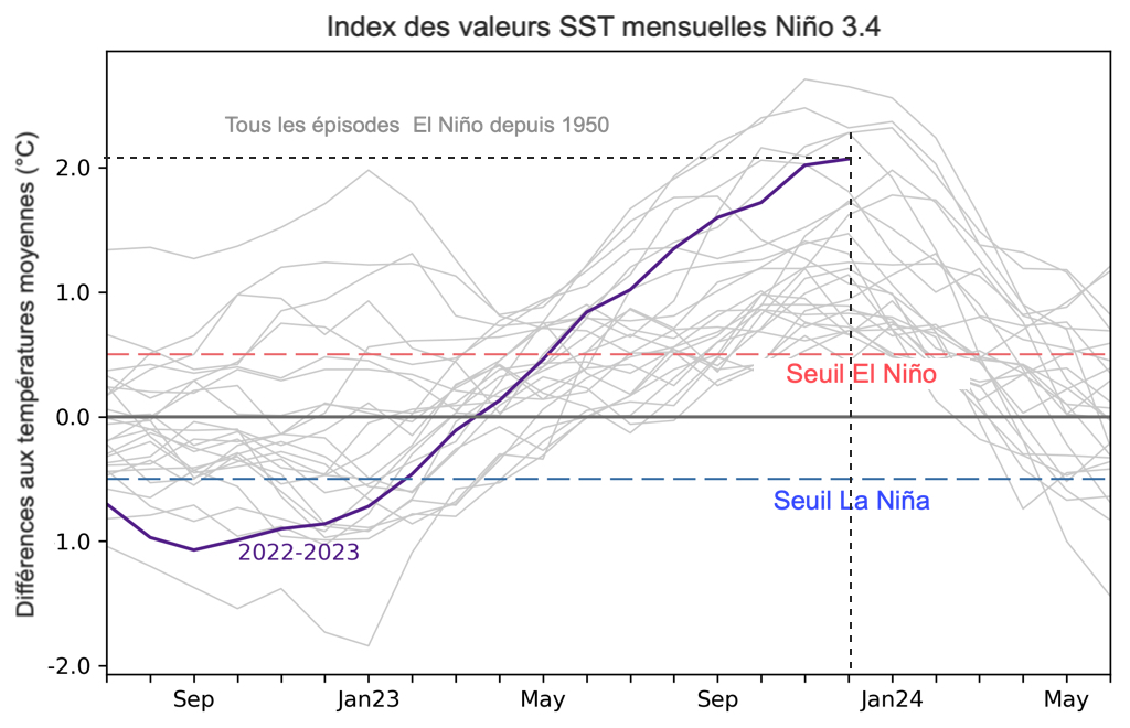
 Following the prediction of an episode El Niño started in March 2023 (¹) and confirmed the following June (²), this climatic phenomenon of the Pacific Ocean, called ENSO (El Niño Southern Oscillation), strengthened until the end of December, early January 2024.
The February ENSO forecast developed by the U.S. Climate Prediction Center predicts that we are on the eve of an episode La Niña, even though the Pacific Ocean is still affected by the El Niño episode. According to the forecast, there is 79 % chance that El Niño will become neutral by April-June, and 55 % chance that the Pacific will return to ENSO La Niña between June and August.
Source : Tom Di Liberto – ENSO Blog / Climate.gov
Currently, El Niño persists in the equatorial Pacific Ocean. In January, sea surface temperatures remained above average across most of the Pacific, although they have declined slightly in the eastern and central Pacific. Monthly values in the Niño-3.4 region – ENSO's main tropical Pacific monitoring region – and the base of the Ocean Niño Index rose from just over 2°C above average in December 2023 down to 1.87°C above average in January 2024.
Overall, the most recent value of the Ocean Niño Index (NOI) – by which NOAA classifies the strength of the events – places the peak strength of this event at ~2°C for the period November to January, This is the fifth highest value in the archives since 1950.
In terms of the atmosphere
We can see that El Niño has weakened a bit over the last month (January). Trade winds have been closer to average in the equatorial Pacific, and if thunderstorm activity remained a bit elevated near the Dateline, it was closer to average in Indonesia, in the Western Pacific. Overall, it seems clear that the El Niño episode has passed its peak. However, it should not be forgotten that the effects of El Niño on global temperatures and precipitation can persist until April.
Beneath the surface of the ocean
Over the entire equatorial Pacific Ocean, average sea water temperatures in the first 300 metres have become close to average again (1991-2020) for the first time in almost a year. It is clear that the colder-than-average ocean waters are rising from the depths and extending eastward, although above-average temperatures persist closer to the surface in the central and eastern Pacific.

Water temperatures in the 300 first few metres of tropical Pacific Ocean compared to average 1991-2020 in December 2023-January 2024. (Animation NOAA Climate.gov, based on data from NOAA's Climate Prediction Center.)
And then ?
The seasonal forecasting models on which climatologists rely are quite confident in the transition from El Niño to ENSO Neutral during the spring 2024 in the northern hemisphere. Then, models generally agree that La Niña will follow over the summer.
Regarding transitions, there's always a bit of uncertainty about the exact timing, because an El Niño can end quickly. De facto, current forecasts only show a difference of two seasons (³) between the end of El Niño (79 % chances in April-June) and the beginning of La Niña (55 % chances in June-August). In addition, this transition can be influenced by unpredictable atmospheric phenomena this early.
–––
(¹) El Niño is back
(²) El Niño strengthens in the Pacific
(³) The term "seasons" refers to successive "rolling" quarters
–––


