iSailor, charts are available for France

isailorSex updated list of new charts available for iSailor, include coasts of France :

∙ Germany ∙ Australia ∙ Bermuda ∙ Canada ∙ Denmark ∙ Egypt ∙ Spain ∙ Estonia ∙ Finland ∙ France ∙ Greece ∙ Italy ∙ Ireland ∙ Latvia ∙ New Zealand ∙ Norway ∙ Papua New Guinea ∙ The Netherlands ∙ Portugal ∙ United Kingdom ∙ Suede ∙ USA : Atlantic Coast, Gulf Coast, Pacific Coast, Hawaiian Islands, Alaska, Great Lakes (U.S. Waters). Read more …

iNavX, application steadily increasing

inavxSince the beginning of the year 2011, not less than six iNavX updates were made by Rich Ray, either one monthly !

If we don't find anything revolutionary there, many “invisible” improvements have been made, as optimizing objects display (waypoints, icônes, tracks, routes, etc,), tracks resolution, convenient improvements on measures of distance, waypoints display, chart available information, alarm management (anchor, TCP/IP disconnect), l’affichage des instruments (analogique ou digital au choix). Read more …

Weather4D 1.1 for iPad and iPhone, at the top.

Two months after out for iPhone, Weather4D (¹), by surprising Olivier Bouyssou, arrives with a version fully optimized for iPad, with the modest release number 1.1.

Cette version unique iPhone/iPad est donc une simple mise à jour gratuite pour les heureux acquéreurs de la version 1.0.

And yet, quel travail il aura fallu pour adapter et optimiser cette application 3D, aussi bien aux écrans et capacités mémoire des iPhone 3 and 4 qu’à celles des iPad 1 and 2, known to be very different ! Read more …

iSailor : Transas maps on iPhone and iPad

iSailorIn France, mariners know little, or not at all, about Transas company of Russian origin. The Transas Group is nevertheless one of the world's leading professional of navigation software . Founded in 1990 in St Petersburgh, it opens its first office in England in Southampton (UK). Application developer for maritime and aeronautical training simulators, leading ECDIS certified designer, AIS network installer, the company has provided its electronic charting systems to prestigious customers, as the Russian space station MIR in 1996. There are countless marine simulator and flight simulators equipped with Transas technology in training centers worldwide. Several major commercial harbours are also equipped with VTS (*) and VTM (*) from Transas.
With 200 million turnover, the now international group, majority run by Russians, has its headquarters in Cork, Ireland.

All this to tell you that, when the very serious Transas company decides to launch a marine charting application on the iPhone and iPad, does not hesitate to rely on a communication, let’s say… particularly impactful. See instead… Read more …

iNavX and SiiTech AIS server

siitechiNavX permet de se connecter, since version 3.1.7 from February the 11 October 2010, to the data server AIS SiiTech which I talked about in a previous post (¹). L’intérêt de ce service restait discutable en France à cause de la faible couverture de nos côtes. Cela pourrait changer.

Indeed, the number of SiiTech ground stations is increasing, les côtes de la Manche sont désormais bien couvertes, et le littoral Atlantique devrait être progressivement équipé (²).

In addition, The version 3.2.4 of iNavX comes with an improvement that makes a revival of interest for this feature : it is now available to select the origin point of AIS data from SiiTech server, soit la position du navire (celle de l’iPhone/iPad utilisé), soit d’un waypoint préalablement créé. Le rayon de réception étant d’environ 30 milles nautiques autour du lieu d’origine, cela permet d’augmenter considérablement la couverture de réception des données AIS.

Read more …

Crossing the Atlantic with an iPad

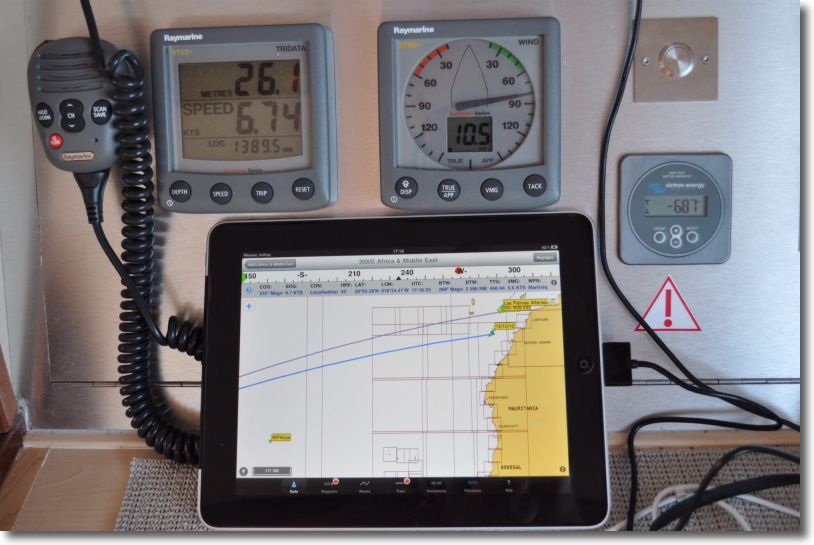
I cannot resist the urge to show you some pics (*) to iNavX on iPad qui vient de traverser l’Atlantique, from Mediterranean to Martinique. The sailor has abandoned his MacBook Air, on which he uses MacENC for several years with S-57 ENC charts. Il a basculé sur un iPad 3G, featured iNavX, Navionics Gold charts and the Apple app Numbers to write his log book.

iPad

iNavX en pleine action

Read more …

Navionics Mobile and Community Sharing

Once will not hurt, I relayed the information in French from Blog Panbo which have interest for Apple mobile devices users.

Community Sharing

  • User Generated Content (User-generated content)
  • Social Mapping or Social Charting (Social Mapping)
  • Crowd Sourcing (Crowd sourcing)

All these english words mean the same principle : sharing to the community all maritime information collected by each charting software user. In other words, each boater can use its navigation application to share all information on any changes observed over charts. This can concern the markup, the erection of a new quay or the appearance of new catways in a harbour, practical information on new harbourt services, incorrect positioning of a rock or the appearance of an uncharted shoal, etc,. Read more …

Marine weather on iPhone

Météo FranceIn a previous post about my favorites apps for iPhone, I cited two weather apps : La Chaine Météo, very good general weather application from Meteo Consult, and iSailing Weather that offers maps of sea-based weather GRIB files from British origin.

Weather France has finally added its own free app, offering its full range of forecasts, including marine weather reports in text format. Read more …

AyeTides – World tides with iPad

AyeTides XL, tides prediction application of Hahn Software LLC, is available since 2 nd August on AppStore. Issue of the software AyeTides for Mac and AyeTides for iPhone, the iPad version offers a completely new user interface to take advantage of the size and definition of the screen.

With more than 12.500 tides and currents stations around the world, dont 160 stations in France, the app presents times and heights of tide level based on the US public software XTide (*) using harmonic data and tidal predictions from the National Ocean Service (NOAA). Numerous corrections have been made in order to obtain predictions with an average of less than 3% deviation from the predictions of official bodies, like the SHOM for France, and database updates are frequent and always free.

Read more …