
Over the last few years, I have expressed myself several times on the quality and reliability levels of the electronic charts we use in yachting., more particularly with the navigation applications of our mobile devices (¹).
Since the oldest article in 2013, It appears seven years later that nothing has really changed. On the occasion of a search for a landing in Galicia, I discover that some publishers have still not updated changes that are almost five years old, like the port of A Coruña, which is so busy. I can always be told that the examples I will cite on the West Atlantic coast do not affect safety in any way., But it gives reason to wonder about the rest of the coastline. It should be remembered that SHOM took nearly a year to update on its raster charts the extension of the port of Minimes in La Rochelle, while the German cartographer NV Verlag had long since represented it perfectly on the NV Charts (²).
I was in A Coruña for the last time at the end of May 2016. The large pontoon that serves the southeast catways was already connected to the land. Today, visible on the BING satellite view, Three publishers on 4 selected from the main, still have not updated their chart ! See the slideshow :


Even the Spanish ENC chart recently available in the Geogarage catalog is not corrected, only Navionics has performed the update..
Going much further north, let's see Saint-Peter's Port in Guernsey, very popular for all North European boaters. The visitors pontoons, once detached from the land, have been for several years now connected by a pontoon allowing land access, without waiting for a spot in one of the usually overcrowded marinas. Here, only the Imray chart is up to date, and partially the satellite view. The most recent satellite image in Google Earth shows the current layout. See the slideshow :


Here, we are perhaps too far from Italy for Navionics to have come to check the place, but the British Admiralty, still !
I come back to A Coruña with another example that, itself, directly concerns security. The opening of this deep bay is blocked by a long bank of rock shoals that can create breakers in strong winds from north to west. Below, only the SHOM map presents explicit information to warn the navigator who does not know the surroundings. See the slideshow :


The repeated annotations "Breakers in heavy seas" and the west and north alignments clearly indicated and annotated make it possible to ward off these dangers., otherwise harmless in good weather or inshore winds. This information is missing on the other charts, this, in turn, has a direct impact on boater security.
I don't really have time to travel all the way to the coast to find other examples, but they are certainly quite numerous. All this confirms to me that we must remain very careful about the use of our electronic charts, and that it is not useless to complete them with regularly updated guides, or at least crosscheck the information with different charts.
If you have examples in your sailing areas, Do not hesitate to share it.
–––
(¹) See the tickets :
– Raster charts... the come back
– Electronic charts : scales and overscale
– Charting compared, a mixed result
(²) NV Chart extends coasts of France from SHOM
–––
On the SHOM map of the Arcachon basin, paper or digitized, the reception and fuel pontoon of the Arcachon marina is badly positioned; it is now more westerly. GoogleEarth makes the same mistake but Bing – whose image dates from 2019 – positions it correctly.
Moreover, even if the access channel to the North Pass frequently varies according to storms, I am surprised that the SHOM persists in not mentioning the location of the buoys. I feel sorry for the boater who wants to enter the basin when he had not programmed it and has to channel by sight without cartographic help…
Bonjour,
Thank you, Francis, for drawing our attention to this specific subject. The solution lies in the use of multiple map sources, including up-to-date paper maps.
However, requests for chart updates by mariners are possible for SHOM charts through the data.shom.fr website. Requests are analyzed and then carried out according to their relevance . After that, these updates will only be visible, on SHOM raster maps, than in the latest version ( 2 yearly) . Some requests are made after several years, the troops are greatly reduced.
SHOM no longer carries out measurement campaigns in our coastal navigation areas, especially not on the foreshore. SHOM focuses on the shipping lines of large vessels subject to SOLAS rules , more than 120m long, as well as to the deep sea with exploitable resources: oil etc …
For Navionics just send an email to help@navionics.com in your native language. You must provide the version of your application and those of your maps, by adding screenshots of Navionics charts (Use the webapp.navionics.com website to make sure you have the latest updates) and SHOM (Use data.shom.fr) . Give the exact location of the problem. Be as courteous as possible. A study will be carried out, Selected updates will be available immediately, provided you have an up-to-date license.
On the data.shom.fr site you can view the current applications according to their type:
-Depth
-Wrecks and Obstruction
-Coastline
-Cables and Conduits
-Names
-Buoys, Tags
-Restricted areas
-Background nature
-Fog lights and signals
You will find the description of the problem provided by the author, Dates and status. Each status has its own color code.
New marinas "forget" to send their new basins and organization of pontoons, as well as the new probe lines. Each one rejects the responsibility for carrying out the measurements.
What will happen to the future wind farms that will soon be around our coasts? Will updates be made as the work progresses or only at the end of the operation? Who will define the exclusion zones, The manager, The Maritime Prefect, DDTM, ..? Who will send this information to SHOM? Normally it is the prefect by an order. With us it's complicated!
For "Cart-tanneur"
I would be interested in placing the location coordinates of these pebbles in the North Cove of Stornoway, I can't find any difference today between the Navionics and UKHO charts
For the Basse aux Chiens north of St Malo, it is advisable when heading for St Malo to leave them on the starboard side, in the west using the alignment at 222 degrees towards the Pointe de la Varde which runs along the cardinal buoy East of Rochefort. If you go around to the north, you have to make a long tour and go well past the cardinal West Rochefort "beacon" which is located on the last usable pebble on this plateau. A cardinal West buoy anchored in the 12m bottom west of the pebbles has never been installed.
Our electronic boards will only evolve with our participation. To your keyboard and mouse!
Hi Francis!
This is a real important thread. I think with all the updates and "latest edition" of electronic charts the navigator is made to believe that he really got the latest and up to date chart from the chart manufacturers. Do you remember: last year the charts from Netherland Hydrographic Institute (NLHO) sold through Geogarage were outdated because the NLHO only updates the electronic chart with every new reprint of their paper chart set.
This year I bought the „latest chart“ from C-map through a Furuno account covering the Baltic Sea. While NV-Charts updated in May about a large new wind park at Kriegers Flak (sailing prohibited in this area) this C-Map chart still doesn’t show any restrictions!
So this C-Map charts are not any better than old paper charts.
Regards, Jochen
Patrice dit:
Naviguant avec un chef de bord en Ecosse dans les Hébrides, nous sortions de Stornoway pour se diriger sur la pointe nord de Lewis avec l’intention de redescendre par la côte ouest de Lewis. Mal nous en a pris, Once we got to this coast upwind in the swell, we came up against a current much higher than that indicated on the charts, so turn around and return to Stornoway. Not intending to be mocked by the very nice Captain Harbour, we have made the decision to anchor in the North Cove of Stornoway. In the engine anchoring phase with Navionics on my iPad, I was quietly heading through the middle of the bay, When the captain downstairs says to me "but where are you going? You have a pebble right in front of you". No stone on Navionics, but my sounder did indicate a sudden rise in the funds ! The captain was controlling my navigation on Maxsea with C-MAP charts, fortunately for us. I sent screenshots to Navionics without ever getting a response. Because indeed there was a superb rock almost flush.
Sailing on the Belle Angèle, old rig which was unfortunately destroyed at the entrance to the Aber Wrac'h, we were returning from the bay of Cancale, after passing the Pointe du Grouin, the Tintiaux from the north before starting to dive back to St Malo, they passed to the north of the Basse aux Chiens. There are two guidelines, an East and a West on the navionics map, after at least a quarter of a mile of the west, I can still see significant eddies on the surface, even though my GPS position allowed me to shoot down. Arnaud, the captain, when questioned, said yes, went even further, The board overflows much more than on the map. Not to mention that normally the danger should be between the two beacons !
In a tide of medium water we walked along the casquets to go to Ste Anne (in the Channel Islands), about Maxsea (MTZ version 2 Well up to date) The currents did not exceed three knots, as we sped off to 6 Surface knots, and we could see the pebbles receding, fortunately the reversal was not too far away !
During the first nautical charts, a French admiral said "nautical charts will make our navigators lose their sense of sea. So electronic maps ???
A big thank you for these instructive feedbacks. About Navionics, here is the page for making an error report. Usually they check. But let's not dream, the countries little frequented by yachting are more neglected than elsewhere. Concerning currents, prediction models in GRIB format such as the MyOcean NWS provided by Weather4D are highly accurate.
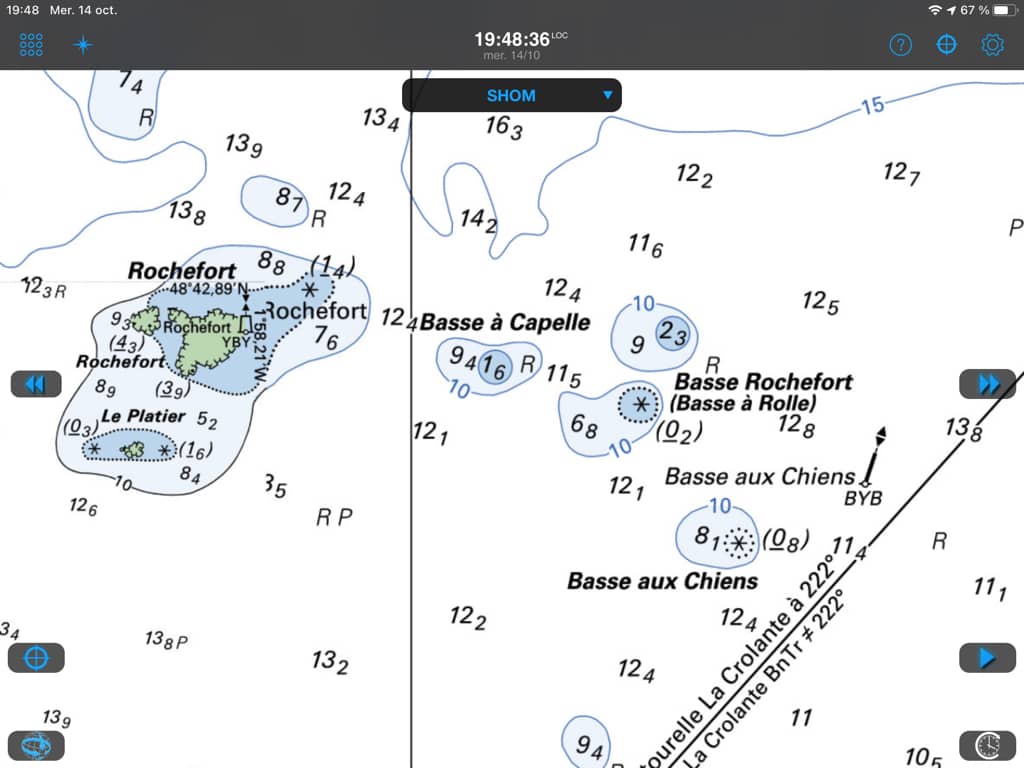
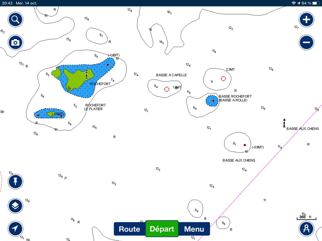
Concerning the Lower Rochefort :
The SHOM map shows that the western turret of the Basse Rochefort must be well parried at a good distance, or better take the alignment to the east of the Basse aux Chiens. The Navionics chart is less precise in its graphics but sufficient to ward off dangers :
They should be held responsible in the event of damage
It's shameful
As usual good info .we wonder why these guys are paid ..
Thank you Francis