 The Pacific Ocean is switching from an El Niño event at the beginning of the year 2024 to a La Niña event expected at the end of this summer. But it seems, for NOAA scientists, that a similar phenomenon is also occurring at this same time in the Atlantic Ocean (¹).
Observation
First of all, it was observed that a large part of the North Atlantic has been extremely warm since the start of the year 2024.

Sea surface temperatures in the North Atlantic on 15 June 2024. Temperatures above 26° Celsius, necessary for the development of a cyclone, are in orange and those below 26° Celsius are in blue. (Image NOAA Climate.gov)
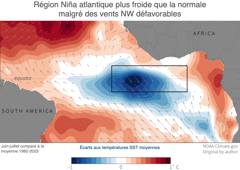
On the other hand, since the beginning of June, sea surface temperature (SST) in the central equatorial Atlantic was 0.5° to 1.0° Celsius colder than average for this time of year. If these cold conditions persist until the end of August, a phenomenon known as Atlantic Niña could occur. But what is the Atlantic Niña and what influence on the weather and climate around the tropical Atlantic? ?

Average sea surface temperatures in June-July 2024 compared to the average 1982-2023 showing cold waters along the equator that could become an Atlantic Niña episode. The black box shows the specific area used for monitoring Atlantic Niños and Niñas. (Image NOAA Climate.gov)
What is La Niña (and El Niño) Atlantic ?
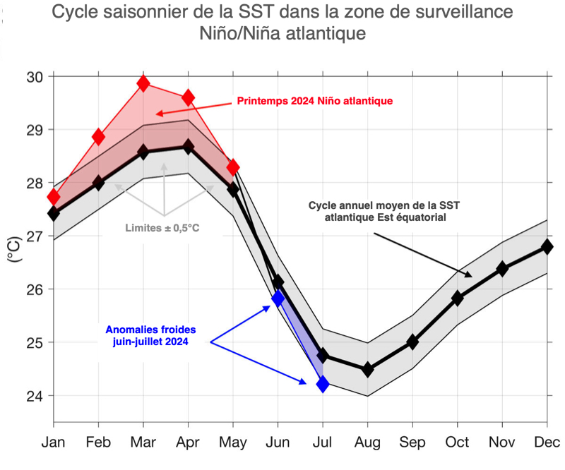
The Atlantic Niña is the cold phase of a natural climatic phenomenon called the Atlantic Zonal Mode. (Zonal meaning “along lines of latitude”). This phenomenon, just like the’ENSO (El Niño-Southern Oscillation), oscillates between cold and warm phases every few years. Generally, sea surface temperatures in the eastern equatorial Atlantic present a rather surprising seasonal cycle : the warmest waters of the year occur in spring, while the coldest waters of the year — less than 25° Celsius — occur from July to August.

Monthly mean SST in the eastern equatorial Atlantic 1982 and 2023 (in black) and in 2024 (red and blue markers). Red colors indicate warmer than normal waters, while blue colors indicate colder than normal waters. The gray area represents the threshold of ± 0.5° Celsius which must be exceeded to qualify as an Atlantic Niño/Niña. Image by Franz Philip Tuchen.
This summer cooling is due to the winds which act on the surface of the ocean. Earth has a year-round belt of precipitation around the tropics. Under the effect of greater solar heating, this belt of precipitation migrates northward during summer in the northern hemisphere. Regular rainstorms draw air from the southeast over the equatorial Atlantic. These regular southeasterly winds are strong enough to push surface water away from the equator, which brings to the surface the relatively cold waters of the deep layers of the ocean. This process, known as equatorial water upwelling (upwelling), forms a tongue of relatively cold water along the equatorial Atlantic during the summer months.
But for several years, this cold tongue is significantly warmer or colder than average due to fluctuations in the Atlantic zonal mode. Cold events are called “ Atlantic Niñas ” and hot events “ Atlantic Niños ”. In general, these sea surface temperature anomalies in the key monitoring area (black frame in illustrations), averaged over three months, must exceed ± 0.5° Celsius for at least two overlapping seasons to be able to speak of an Atlantic Niño or Niña.
From the beginning 2024 to August 2024
The year 2024 started with sea surface temperatures (SST) extremely hot in the eastern equatorial Atlantic in February and March, with temperatures exceeding 30° Celsius. This is the most significant heat episode since 1982. The rapid transition between warm and cold sea surface temperature anomalies was equally remarkable. Never before in observed records, the eastern equatorial Atlantic had never switched so quickly from one extreme phenomenon to another.
![Click to enlarge..tfromhighest red barwas the strongestThe Atlantic Niñoto July À gauche] Températures mensuelles de surface de la mer comparées à la moyenne dans la région clé de surveillance du Niño/Niña de l'Atlantique entre janvier 1982 et juillet 2024. Le Niño atlantique de 2024 a été le plus fort (barre rouge la plus haute) depuis 1982. [À droite] Les températures dans l'est de l'Atlantique équatorial étaient juste en dessous du seuil Niña en juillet 2024.](https://navigation-mac.fr/wp-content/uploads/Nino-Nina/NinaAtlantic/4.atlantic-nino-index-1982-2024.jpg)
[Left] Monthly sea surface temperatures compared to average in the key Atlantic Niño/Niña monitoring region from January 1982 to July 2024. The Atlantic Niño 2024 was the strongest (highest red bar) from 1982. [Right] Temperatures in the eastern equatorial Atlantic were just below the Niña threshold in July 2024.
However, in a surprising way, cold anomalies observed in the eastern equatorial Atlantic in June/July 2024 coincide with a weakening of the southeast trade winds near the equator. Slackening equatorial winds is generally associated with a reduction in upwelling and warm anomalies, which was obviously not the case.

Winds were not particularly favorable for upwelling in the key monitoring region (black frame). This summer, the area suffered an unusual influence from northwest winds (gray arrows) weakening the normal southeast trade winds which normally favor the rise of cold, deep waters at the level of the equator. Source : NOAA Climate.gov.
It is only south of latitude 5 degrees South that the southeast trade winds were stronger than usual. From now on, these atmosphere-ocean conditions, apparently unfavorable to the development of the Atlantic Niña, leave us perplexed. We will have to dig deeper to know the exact causes of this apparently unusual event..
Plus or minus 0.5°, what does it matter ?
One might think that a temperature gap of ±0.5° Celsius in the tropical Atlantic is not very important. In reality this difference may have a considerable impact on precipitation on surrounding continents. The decrease in precipitation in the Sahel region, increased precipitation in the Gulf of Guinea and the shift of the rainy season to northeastern South America, all these events have been attributed to the Atlantic Niño phenomenon.
Furthermore, Atlantic Niños have been shown to increase the likelihood of strong cyclones developing near the Cape Verde Islands. NOAA's seasonal forecast for above-normal hurricane activity in 2024 are based in part on the La Niña conditions expected in the equatorial Pacific and on high ocean temperatures in the tropical North Atlantic (²). It will be interesting to observe if this Atlantic Niña fully develops and, if applicable, whether it has a moderating effect on hurricane activity as the season progresses
NOAA will be monitoring this event in the coming weeks and will publish a follow-up article later this month to let you know if an Atlantic Niña has fully developed.. The agency will also examine some of the hypotheses put forward by scientists to explain how these phenomena trigger and how human-caused global warming could affect their frequency over the coming century.. Stay tuned !
–––
(¹) Source : NOAA
(²) After El Niño 2023 here is La Niña 2024
–––


Very interesting.
Probably impactful for navigation between the tropics.
The probability of cyclonic developments around Cape Verde particularly.